News
Beyond the Video: How LiDAR and SONAR Map Large Diameter Pipes with the CUES SoLID FX System
If you are managing a large diameter sewer interceptor, something 60 inches or wider, and you are relying solely on a standard CCTV camera to tell you if that pipe is going to collapse, you are not inspecting. You are guessing.
Here at RAVAN AIR we have seen what happens when facility managers rely on grainy video to make million-dollar decisions. A camera lens has limits. It cannot see through murky sewage water. It cannot tell you if the pipe wall has lost an inch of concrete due to corrosion. It cannot give you the math you need to predict a failure.
For years, the only way to get real data was to drain the pipe. You had to set up massive bypass pumps, divert the flow, and send a person or a crawler in. That costs a fortune. It disrupts the community. It is a headache.
There is a better way. It is called the CUES SoLID FX System. At RAVAN AIR, we do not just take pictures of your pipes; we map them with science. By combining LiDAR lasers, profiling SONAR, and HD video, we can inspect your lines while they are still full of water. No bypass pumping. No guessing. Just hard, actionable data.
Here is how we do it and why it matters for your bottom line.
What is the CUES SoLID FX System?
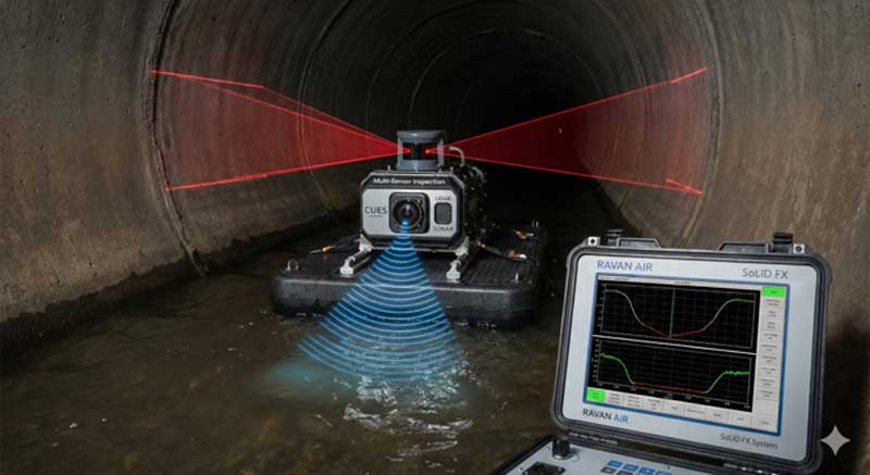
To understand why this system is different, you have to understand what “SoLID” stands for. It means Sonar Light Identification. It is not just one tool. It is a Multi-Sensor Inspection (MSI) platform that combines three different technologies into one rig.
Think of a standard sewer robot like a flashlight. It shows you what is in front of you. The CUES SoLID FX is more like an MRI machine for your pipes. It carries three distinct sensors:
- HD CCTV Camera: This gives us the visual feed we are used to. We use it to spot cracks, infiltration, and roots..
- 2D LiDAR Sensor: This uses laser light to measure the shape of the pipe above the water.
- Profiling SONAR: This uses sound waves to measure the shape of the pipe below the water.
We can mount this system on a robotic crawler, like the CUES Steerable MudMaster, if the pipe has low flow. But for those big, high-flow interceptors that are half-full of water, we mount it on the SFX FLOAT. This is a stable raft that floats down the pipeline.
Because we have all three sensors working at the exact same time, we get a complete 360-degree view of your pipe. The camera sees the defects. The LiDAR measures the dry walls. The SONAR maps the submerged bottom. When we put it all together, we know exactly what is happening inside your infrastructure.
The Science: How LiDAR and SONAR Work Together
You might be asking, “why do I need lasers and sound waves? Can’t I just look at the video?”
The answer is no. Video is subjective. If you look at a video of a concrete pipe, you might see that the wall looks rough. But you cannot tell if that roughness is just surface wear or if you have lost two inches of concrete. That is where the science of LiDAR and SONAR comes in.
Above the Water: The Power of LiDAR
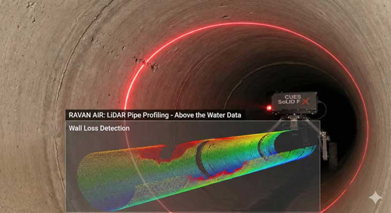
LiDAR stands for Light Detection and Ranging. It is the same technology used by self-driving cars to see the road.
Here is how it works in a sewer. The LiDAR sensor shoots a laser beam out in a ring. It does this thousands of times per second. The light hits the pipe wall and bounces back to the sensor. The machine measures exactly how long it takes for the light to return. This is called the “time-of-flight.”
Since we know the speed of light, we can calculate the exact distance from the sensor to the wall.
Why is this useful? Imagine your concrete pipe is being eaten away by sewer gas. This is called biogenic corrosion. The hydrogen sulfide gas (H2S) turns into acid and eats the concrete crown (the top) of the pipe. A camera just shows you a dark, rough surface.
The LiDAR creates a perfect cross-section profile. It draws a line that represents the actual shape of the pipe. If the pipe is supposed to be round but the top is flat or eaten away, the LiDAR data shows it instantly. We can overlay the “perfect” circle on top of the actual scan. If there is a gap, that is wall loss. We can tell you, “You have lost 1.5 inches of concrete wall at the 12 o’clock position.” That is data you can use to plan a repair.
Below the Water: The Precision of SONAR
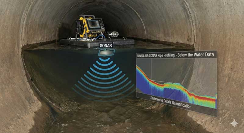
LiDAR is amazing, but it has one weakness: it cannot see through water. The laser beam hits the water surface and scatters. That is why we need SONAR for the bottom half of the pipe.
SONAR works just like the LiDAR, but it uses sound instead of light. The sensor sends out a high-frequency sound ping (around 2 MHz). This sound travels through the water, hits the bottom of the pipe, and bounces back.
Sewer water is often murky and full of solids. A camera sees nothing but brown water. But high-frequency sound cuts right through the turbidity. It hits the hard pipe wall (or the debris sitting on it) and returns a clear signal.
This allows us to “see” the bottom of the pipe even when it is full of sewage. We can measure the shape of the pipe invert. We can see if the pipe has sagged or if there is a hole in the bottom. Most importantly, we can see the sediment.
Why “Live Flow” Inspection Changes the Game
The biggest advantage of the CUES SoLID FX system is that we do not need to stop the flow. This is a massive economic benefit for municipalities and industrial plants.
In the old days, if you wanted to inspect a 60-inch interceptor, you had to bypass pump. You had to bring in huge diesel pumps and lay miles of temporary hose to route the sewage around the section you were inspecting.
Bypass pumping is incredibly expensive. On many projects, the bypass pumping costs more than the actual inspection or repair! It can take up 30% to 50% of your total budget. It also carries risk. If a pump fails, you have a spill.
With the SoLID FX system, we put the sensors on a raft and float them down the live pipe. The sewage keeps flowing. The toilets keep flushing. The system keeps working.
We collect all the data we need, visual, LiDAR, and SONAR, without disrupting your operations. This saves our clients thousands, sometimes millions, of dollars. It also makes the inspection much faster. We can inspect thousands of feet of pipe in a single day because we do not have to wait for the pipe to drain.
Actionable Data Deliverables
When RAVAN AIR finishes an inspection, we do not just hand you a USB drive with some video files. We give you engineering data. Because we use the CUES SoLID FX software, we can provide reports that actually help you plan your maintenance.
Here is what you get:
- The Flat Graph: Imagine if we took your pipe, slit it down the middle, and unrolled it flat like a map. That is a flat graph. It shows the entire length of the pipe in one view. You can see exactly where the corrosion starts and stops. You can see where the debris piles up.
- 3D Point Clouds: We can give you a 3D model of your pipe. Your engineers can bring this into CAD software. They can rotate it, slice it, and measure it. It is a virtual twin of your infrastructure.
- Sediment Quantification: This is critical for cleaning contracts. Since the SONAR measures the sediment depth at every inch, we can calculate the exact volume of debris in the pipe. We can tell you, “There are 50 tons of sand in this section.” This prevents contractors from overcharging you for cleaning. You know exactly how much material needs to be removed before they even start.
- RUL Reports: RUL stands for Remaining Useful Life. By taking the wall loss data from the LiDAR, we can calculate how much strength the pipe has left. We can predict if the pipe will last another 20 years or if it will fail in 2 years. This helps you prioritize your budget.
Commonly Asked Questions about LiDAR and SONAR?
In my line of work, I get asked a lot of questions about this technology. Here are some of the most common ones.
“What is the difference between laser profiling and LiDAR in sewers?”
Laser profiling often just uses a ring of light that is recorded by the camera. It relies on the camera’s perspective, which can distort the image if the angle is wrong. LiDAR is different. It measures the actual “time of flight” of the light pulse. It is a true distance measurement, not just a visual trick. LiDAR provides true 3D data that is far more accurate for engineering calculations.
“Can SONAR really see through thick sewage?”
Yes, it can. Light scatters when it hits particles in the water, which is why cameras fail in dirty water. Sound waves are different. The acoustic pulse used by the CUES SONAR is designed to travel through water. While extremely heavy sludge can absorb some signal, for 99% of sanitary sewers, the SONAR cuts through the murky water and finds the hard bottom clearly.
“Why use multi-sensor inspection for large pipes?”
You use it because large pipes carry the most risk. If an 8-inch pipe collapses, it is a problem. If a 90-inch interceptor collapses, it is a catastrophe. Multi-sensor inspection gives you the confidence to know the true structural condition. It eliminates the blind spots of standard CCTV. You cannot afford to guess with critical infrastructure.
Conclusion: Data Integrity for the Future
At RAVAN AIR, our core values are innovation, data integrity, and competence. The CUES SoLID FX System embodies all three.
We are moving past the era of simply looking at defects. We are entering an era of measuring them. With LiDAR mapping the dry pipe and SONAR mapping the wet pipe, we provide a complete, holistic view of your underground assets.
We do this because we believe that safe communities rely on safe infrastructure. You cannot fix what you cannot measure. By using this advanced technology, we help cities and industries extend the life of their pipes, save money on unnecessary bypass pumping, and prevent catastrophic failures before they happen.
If you manage large diameter pipes, stop relying on simple video. It is time to look deeper. It is time to use the science of sound and light.